THE CHALLENGE OF ORUC REIS IN SE MEDITERRANEAN-
AN OVERALL EVALUATION
Introduction; The Turkish exploration vessel “Oruc Reis” of Turkey, whose recent activity in the SE Mediterranean has aroused great interest, conducted a seismic exploration project from 9/8/2020 to 29/11/2020, in an area south of Kastellorizo and east ofthe meridian of 28°. This survey aims to interpret Oruc Reis’ goals , after evaluating its movement.
Known Facts;
The vessel began its operations, accompanied by two auxiliary vessels of the “supply boat” type (ATAMAN, CENGIZ HAN) as well as five warships. With two successive groups of NAVTEX announcements, such as 977/20, 1083/20, 1095/20, 1262/20, 1314/20 and 1332/20, 1364/20, 1404/20, 1460/20, it covered an area of approximately 57,000 sq. km twice, within which it executed two groups of seismic lines with vertical directions of the potential length of about 9,000 km. (Figures 1,2,3). These had the following features;
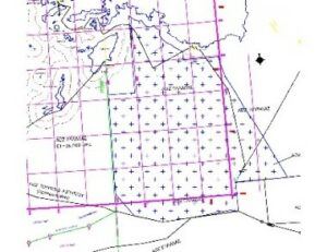
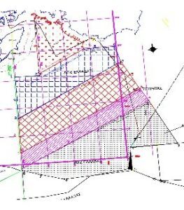
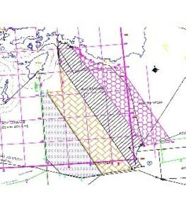
Figure 1: The first five NAVTEX Figure 2: Total drive area of Oruc Reis Figure 3: The remaining four NAVTEX
- They were about 4-6 nautical miles apart.
- The total length of the lines recorded by this operation in the first group was about 4,800 nautical miles, while in the second one it was approximately 2000 nautical miles (due to emission interruptions of the AIS positioning system) (Figure 4 and Table 1).
- Because of a non-stop movement of the vessel, at about 4.5 mph, for 83 days long, we can easily conclude that it made nearly 108 nautical miles per day, which is a potential record total of about 9,000 nautical miles. In fact, recording routes with a total length of about 6,800 nautical miles was well possible.
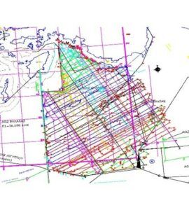

Figure 4: All seismic lines Table 1: Features of the seismic survey of “ORUC REIS”
The nine NAVTEX issued in the same area have certain characteristics that should be studied and evaluated for their significance such as:
- They attacked the potential territorial sea of Kastellorizo that accounts for 12 nautical miles (Figure 5).
- All NAVTEX, in their western regions, left an area on the north side out of exploration, with extreme diligence and accuracy (Area A – red color) (within the Turkish-Lybian memorandum)
- of a total area of 2,900 sq.km (Figure 7).They were identified within the area defined by Turkey’s concessions to TPAO (Türkiye Petrolleri Anonim Ortaklığı) in 2012, 2013, (Figure 6),
- The design of NAVTEX 1332/20 and 1404/20 at their southern end raises important questions about their significance.
- 4. Point 15 of NAVTEX 1460/20 (as well as Point 2 of NAVTEX 1314/20) southwest of Kastellorizo (Figure 10), is very close to its territorial waters and needs to be inspected with more precise methods whether it is in or out of them because it cannot be determined with the discretion of the present method. If it’s in, then it’s probably in that way that Turkey will interpret our possible silence as an acceptance that territorial waters are also in question.
Interpretation of vessel activity;
Based on the above objective and indisputable facts, we note that;
- A false impression of lawfulness covers the whole activity, that is an area within the Turkish Continental Shelf is being investigated, on the grounds that it ignores the right of the continental shelf on the islands.
- Turkey, based on the Turkish-Lybian memorandum, could proceed with the exploration both West of the meridian 28° or and in area A (Figure 5). The non-violation, so far, indicates that there may have been some kind of agreement between the parties involved (Greece, Egypt, USA, Turkey perhaps, and others) on the activity and sovereign rights on and on the meridian 28°.
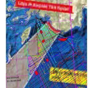
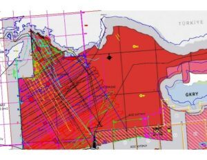
Figure 5: Area within Turkish-Libyan memorandum Figure 6: Association of concessions in 2012, 2013 with ORUC survey
- Furthermore, a small triangular area southwest of the surveyed area of NAVTEX 1332/20, an area of 390 sq. km. (Figure 7), was excluded from it. This area is above point 8 of NAVTEX 977/20, a point that belongs to the delineation line of the EEZ between Greece and Egypt (the easternmost). Egypt has previously expressed the view that this is in its own EEZ. Based on this point (if not modified) questions arise as to what is expected to be the continuation of the delineation line of the EEZ between Greece and Egypt east of the meridian 28°.
- The first NAVTEX 977/20 has been designed in such a way as to challenge the ownership of the area where the EEZ of Greece and Cyprus would theoretically unite, when deciding their common delineation, on the west side of the Cyprus sea Block 4 (Figure 8).
- Point 14, as well as part of the line of the exploration program in NAVTEX 977/20 (Figure 9-green lines), is within the area of Block 4 of the Republic of Cyprus. The peculiarity of the southern section of NAVTEX 4104/20 is likely to be a sign of challenging its ownership and preventing foreign companies from participating in the event of its announcement by Cyprus.
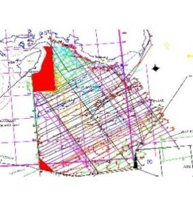
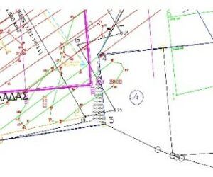
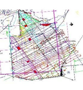
Figure 7; Areas excluded from the survey Figure 8; Plot invasions of Block 4 Figure 9; Basic squares
- 6. Parallel within the same NAVTEX and at its northern end (Figure 10-Purple Line-points 14,15,16,17,18,19) a peculiar record of seismic profiles (red lines 231, 232,…249, 250, 251) was observed, which are not only justified as turns of the vessel due to the approach of the north end (16,17,18,19) but show that an attempt (that is not scientifically correct) to collect more data outside the six nautical mile limit of Kastellorizo without any violation, is made.
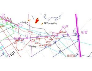
Figure 10; Peculiar seismic activity at the northern end of NAVTEX 1460/20
Conclusions;
- Turkey, with a carefully planned and progressively evolving through successive nine NAVTEX exploration effort, surveyed an area of approximately 57,000 sq.km., south of Kastellorizo and east of the meridian 28°twice with two successive NAVTEX groups .
- The distances between the seismic profiles create a canvas with an area of the resulting elementary squares from 70 to 140 sq. km. (red parallelograms-figures 5,9). The fact indicates that this is a reconnaissance program.
- This exploration collected a huge amount of geophysical data and information on a potential line length size equal to 9,000 nautical miles. These data can serve as a negotiating tool and also determine the type of “possible concessions” that Turkey will be forced to make in the event of future arrangements under its “magnanimity”, in areas that it now knows to be of no interest.
- The exploration has avoided (at least until now) getting into area A and a legally delineated area between Greece and Egypt west of the meridian 28°, as well as proceeding south of its own unilateral and arbitrary delineation of the EEZ with Egypt on the east side of the meridian 28°, respecting an apparent legality, which, in essence, is at its favour.
Taking into consideration the above mentioned, it is reasonable to claim that the activity of the vessel, ultimately, aimed mainly, to the questioning of the sovereign rights of Greece in this region and less to the oil exploration, giving obvious signs that it is probably pre-agreed with third parties.
This venture leaves some room that perhaps it could be modified in a small range in the future, in order to partially satisfy the demands of Greece and Egypt, under a veil of “legality” and “ magnanimity”, on its part. In fact, of course, it would be the only one to win, given that it could potentially acquire sovereign rights in most of the investigated area, acquiring common points of contact in the sea area of the Eastern Mediterranean with Egypt and cutting off the Union of the EEZ of Greece and Cyprus since the complex of Kastellorizo for it (and not only) is ignored, as far as its rights to EEZ and Continental Shelf are concerned.
Leontios K. Portokalakis
Surveyor Eng., M.Sc.
Member of HEL.I.S.S.